Channel Islands National Marine Sanctuary Featured Teacher At Sea
The mission of NOAA's Teacher at Sea (TAS) program is to give teachers a clearer insight into our ocean planet, a greater understanding of maritime work and studies, and to increase their level of environmental literacy by fostering an interdisciplinary research experience.
Our currently featured Teacher at Sea is Sarah Raskin. Below is the blog from her recent Bell M. Shimada cruise in CINMS.
DAY ONE
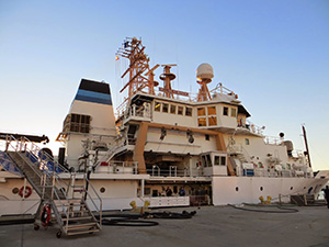
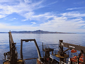
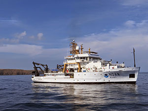
The Bell M. Shimada, my home away from home for the next six days! Today marks my first official day aboard the Shimada as part of NOAA's Teacher at Sea Program. NOAA stands for National Oceanic and Atmospheric Administration. My name is Sarah Raskin and I am an educator at Haydock Academy of Arts and Sciences, a public middle school in Oxnard, CA. For the next week, I have the opportunity to join NOAA scientists from across the United States on a deep-sea science expedition in the Channel Islands National Marine Sanctuary. I am hoping to bring back what I learn to the students at Haydock and to paint a picture of what it is like to work on real-life science out in the field.
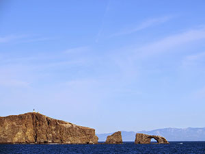
The location for our expedition is in the waters off of the coast of Ventura and Santa Barbara counties in Southern California. The Channel Islands National Marine Sanctuary (CINMS) covers 1,470 square miles of water surrounding Santa Barbara, Anacapa, Santa Cruz, Santa Rosa, and San Miguel Islands and is home to a large amount of diverse species. On this expedition, scientists will use an ROV (a remotely operated underwater vehicle) to examine deep-sea coral and the water chemistry around those coral beds. One of the most surprising facts for me before beginning this journey was to learn that coral grows in cold water deep-sea habitats, having only previously associated coral with warm water environments.
During this expedition, scientists will also look at how the corals are affected by ocean acidification. It will be interesting to see what their findings are: how do our actions on land affect organisms, such as coral, that live in the deep sea?
The scientists will collect live samples of the coral to take back to their labs for further ocean acidification testing.
Throughout this trip, scientists will also use sonar to map the ocean floor. The information gathered from the sonar will help provide direction for where to send our ROV. The new images generated from the sonar could also be used to bring up-to-date sea floor maps of the Sanctuary, many of which have not been updated since they were created in the1930s! Another feature of the sonar is to map out locations and quantities of fish populations in the area. This information is vital to sanctuaries and marine protected areas, as it contributes important information about why these areas are important to protect.
Science in the field is much different than science in a laboratory setting. There are so many factors to take into account: weather, ocean conditions, the working conditions of the equipment and many more unforeseen circumstances. The scientists and ship crew must each do their parts and work closely together as a team to make the research possible. During the first day aboard the researchers have faced quite a few challenges... Maybe because we set sail on Friday the 13th?
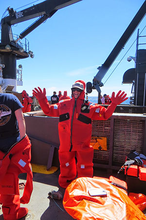
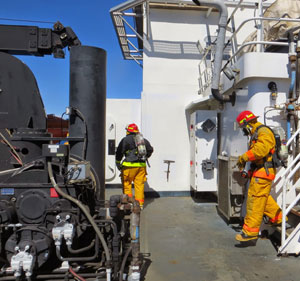
The morning began with impromptu safety drills. Similar to the fire drills that we have at our school, the ship also conducts regular drills. Today we had both a fire drill and an abandon ship drill. The abandon ship drill prepares the crew for an emergency event that would require us to leave the ship immediately. It also involved donning a safety suit, a giant red neoprene wetsuit that is designed to keep you warm if you needed to jump into the ocean.
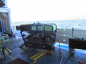
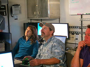
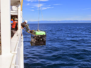
Later in the afternoon, the team took the ROV out for its first outing of the trip. Chris Caldow (the expedition lead) and the scientists from Marine Applied Research and Exploration (MARE) chose a spot on the ocean floor that was sandy and flat with few physical features to snag on for its initial run. The ROV, which is named the Beagle, is an amazing piece of machinery. It is designed to be able to function in depths of down to 500 meters. It is also equipped with a high definition video camera that will take footage of what is going on under the sea. If the scientists see something of interest, the Beagle ROV has a manipulator arm to collect samples. The arm feature is also used to deploy different types of sensors that will keep track of information, such as temperature, over a longer period of time.
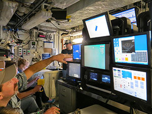
The launch of the ROV was exciting. Most of the crew gathered around to watch its release, and as it made it's way down to the sea floor, it began streaming video footage to monitors inside of the laboratories on the ship. It was pretty incredible to be able to see the bottom of the sea floor with such clarity. So far, we have spotted multiple species of rockfish and an egg case of a skate. I can't wait to see what tomorrow will bring!
Back to one of our challenges: the key sonar machine is currently out of order. When things break on a ship, it can be a bit tricky to fix. It's definitely not as simple as running to the nearest hardware store to pick up a new piece of equipment. When something is not working out here, it can involve scuba diving under the ship to fix something or sailing back to the mainland if there is a real issue. So tomorrow there will be a boat coming out to meet our ship and bringing with it equipment and a trained sonar technician to hopefully solve our problems. Let's keep our fingers crossed!
Update: Science in the Field
The Beagle ROV journeyed into the depth once more last night. This time the mission was to find deep-sea coral beds, in particular one species called Lophelia pertusa, and bubble gum coral.
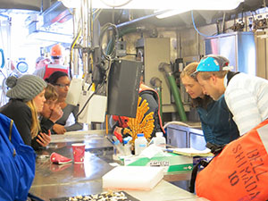
The MARE team (Dirk Rosen, Andy Lauermann, Steve Holz and Rick Botman) worked with scientists Peter Etnoyer, Leslie Wickes, Andrew Shuler and Branwen Williams to locate a coral bed that they had visited previously in 2010 and 2014. Using GPS coordinates, the MARE team was able to locate the exact site of the coral bed that Peter and his team had worked with in earlier years. There were quite a few high-fives and cheers of excitement in the lab when the ROV made its way to the familiar patch of bright red bubble gum coral.
The team dropped a temperature gauge at that location that will take and record a temperature reading every five minutes for the next six months. After that, Peter and his team will return on a second expedition to retrieve the device. The temperature gauge is tied to a rope attached to a lead weight and a flotation device covered with bright reflective tape. Andrew explained that the reflective tape would stand out in the headlights of the ROV, making it much easier to spot when they return for it half a year later.
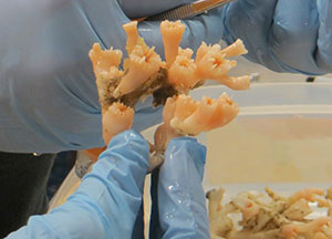
The Beagle also retrieved its first coral sample of Lophelia pertusa, which it brought to the surface. Picking up samples from the deep in no easy feat. Andy and Dirk control the ROV from the deck with controls that look similar to something you would find on a video game consul. Sitting along side them, scientists Peter, Leslie and Branwen direct them to which coral specimens look the best for their sample. Then using either the manipulator arm or a shovel like feature on the boat, the ROV controller works quickly to scoop the organism into a basket attached to the front of the machine.
Once the ROV safely made it back on board, the scientists worked quickly to get the coral and its little inhabitants such as deep-sea brittle stars and crabs, into cold water tanks as fast as possible. While the coral doesn't seem to mind the pressure difference between the deep-sea and surface, it does not handle the temperature differential as well.
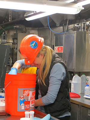
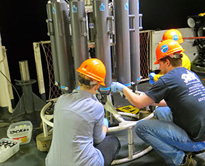
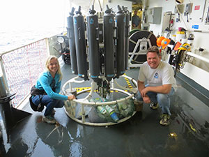
The team also took water samples from the water near the coral sites, which they will test later for pH. They are hoping to find out whether coral changes the composition of the water surrounding it. In order to collect the water samples, Branwen Williams (a scientist and professor from Keck Science Department at Claremont College), Leslie and Andrew retrieved water samples using a CTD-niskin rosette. They took water samples at the depth of the coral beds (approx. 290 meters) and then every 25 meters up from there. Once they filled bottles with the water, it was important to immediately "fix" the water samples. This means putting a poison, such as mercuric chloride into the water sample to kill off any living organisms, such as zooplankton or phytoplankton, that might be photosynthesizing or respiring and changing the pH levels of the water samples. This gives the scientists a snapshot of what the water chemistry is like at a particular place and time.
DAY TWO
Happy Pi Day everyone! The second day on the ship was productive and incredible. The weather was fantastic throughout the entire day, with hardly any wind and a sheet glass ocean. The stillness of the water made it easy to spot wildlife, and during the day we saw multiple pods of dolphins, sea lions, and a variety of sea birds such as cormorants and brown pelicans.
The beautiful weather also made for smooth conditions to launch the ROV. The ROV took three dives today at different locations and depths each time. Peter and his team picked the locations around the Islands, staying true to spots they had visited in previous years. Part of their research involves looking at the same coral beds over the course of many years and recording what they observe and noting any changes that may have occurred. They are observing how the coral, specifically the species Lophelia pertusa, reacts to changes in pH levels and temperature. This information is important in finding indicators for how our ocean is being affected by warmer temperatures and ocean acidification.
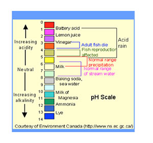
So what exactly is Ocean acidification? As humans, we release carbon dioxide (CO2) into the atmosphere and have been doing so in large quantities since the Industrial Revolution. Carbon dioxide is released during combustion, when we drive our cars, power our houses and factories, use electricity, burn things, cut down trees, etc. The ocean acts as a sponge and absorbs about 30 percent of the carbon dioxide from the atmosphere. However, as levels of CO2 rise in the atmosphere, so do the levels of CO2 in the ocean. This is not great news for our ocean or the organisms that make their home there. When CO2 mixes with seawater, a chemical reaction occurs that causes the pH of the seawater to lower and become more acidic. This process is called ocean acidification. Even slight changes in pH levels can have large affects on marine organisms, such as fish and plankton. Ocean acidification also reduces the amounts of calcium carbonate minerals that are needed by shell-building organisms to build their shells and skeletons. The damage to these shell-building organisms, including many types of plankton, oysters, coral, and sea urchins, can have a negative ripple effect throughout the entire ocean food web. An important part of the mission of this trip is to see how ocean acidification is affecting different types of deep-sea coral, such as Lophelia pertusa, that use calcium carbonate minerals to build their skeletons.
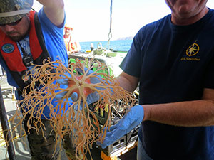
The scientists and the MARE team conducted three ROV dives throughout the day. The first dive brought up an outstanding Lophelia sample, and along with it a bizarre deep-sea creature called a basket star. Basket stars are a type of invertebrate that are related to brittle stars. Even though they feed mostly on zooplankton, they have long spindly arms that can reach to over a meter in length. It was astonishing to be able to see this alien looking creature alive and moving!
DAY THREE
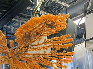
Sunday 3/15/15: After long hours and a late night, the MARE team was able to get the manipulator arm on the ROV up and running, after having technical difficulties with it during the first half of our trip. This was perfect timing for the first ROV dive of the day in the waters between Santa Cruz and Anacapa Islands. The goal of this dive was to find scientist Branwen Williams a type coral known as acanthogorgia. This coral is incredibly beautiful; tall, fan-like and golden in color.
Diving Deep: The ROV was dispatched into the water and soon sunk to around 200 meters. As it cruised along the ocean floor the team watched as a variety of rockfish scuttled by. The ROV has two sets of lasers that shoot out in front of it, each spaced 10 centimeters apart. This gives the scientists an idea of the size of objects or organisms that pass in front of the camera.
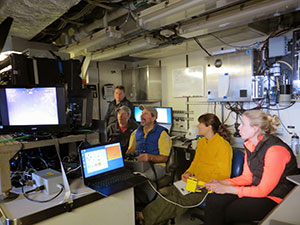
The team located the Acanthogorgia habitat and got to work collecting samples using the manipulator arm. The manipulator arm reminds me of the claw game found in most arcades. Andy remotely operated the arm, while Dirk worked simultaneously to control the ROV. Together they were able to collect three exceptional samples, including two Acanthogorgia corals attached to hefty rocks. Each time the manipulator arm reached towards a coral, the whole crew of the Shimada held in their breath in suspense. Would the arm be able to grasp its target? The live footage from the ROV is now being streamed throughout the entire ship; in the lounges and staterooms too, so Andy and Dirk had a quite an audience cheering them on!
The samples made it back to the ship safely. Branwen prepared the coral to take back to the Keck Science Department of the Claremont College where she and her students will conduct their research about this little known species of coral. Thinking about the effort it takes to research deep-sea coral; involving ROVs and commissioning ships to reach their remote locations, it's no wonder we know little about them and so much more about their shallow water relatives.
DAY FOUR
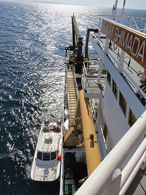
The visiting sonar technician left this afternoon on NOAA's Shark Cat boat after working diligently to fix the ship's sonar system throughout the past few days. As of now, the ME 70 sonar is up and running. This equals exciting news for the sonar team that has been waiting patiently to begin their projects. The Shimada actually has two sonar machines; one works with a single beam, while the other, the ME 70 has multiple beams that can cover a much greater amount of territory in the same amount of time.
How does sonar work? Sonar technology is a way for us to create images of what is below the surface of the ocean. The sonar system, which is attached to the bottom of the ship, sends out an acoustic signal towards the ocean floor and then measures how long it takes for the sound to bounce back to the boat. By measuring this, the sonar creates a picture of the depth of the ocean floor in that area.
A secondary measurement that is also occurring when the sonar machine is running is called backscatter. Backscatter measures the intensity, or loudness, of the sound as it echoes back to the ship. The softer the sound when it reflected back means the softer the type of surface it is bouncing off of, such as sand. The louder and more severe the sound is equates to a harder surface floor, such as rocky ledges. As Andy explained to me, think about bouncing a ping-pong ball on a carpet vs. hardwood floor. The ping-pong ball will have a much stronger bounce off of a hard surface v. a softer one. Will also explained that based on the backscatter sound we can determine fine details such as whether the sand is fine or coarse.
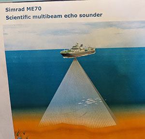
Both of these sonar features create an image of what the ocean floor looks like, its physical features, habitat types and any potential hazards that may exist below the surface. This is critical for creating nautical charts and it is also important for the navigation of the ROV, so it doesn't stumble upon any unexpected obstacles while traveling underwater.
Another feature that sonar is used for on this ship is to measure fish abundance. The sound waves travel down and bounce off of the fishes' swim bladders. Swim bladders are gas filled bladders found in many fish that helps them stay buoyant. Using this method, scientists could use sonar to gauge fish populations, instead of catching fish to see what is out there.
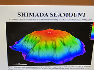
So far in the trip, Laura Kracker and her team (Mike Annis, Will Sautter and Erin Weller) have been using the working sonar to map fish populations in the area. Tonight, however, they will use the ME 70 for a test run to map out areas of the Channel Islands National Marine Sanctuary that have never been mapped before! This data could be used to create brand new nautical maps, to help scientists have a better idea of what the hidden part of our sanctuary looks like and to determine which regions might be best habitats for fish or coral. Tomorrow, the ROV team will send the ROV to the sites that were mapped the previous night to check out features that were discovered on the seafloor and to explore the newly mapped regions.
When setting out on this journey, students asked me what life would be like living on a ship. I spoke with several of the crew members on the ship about what it is like to be out at sea for days at a time. So here is an image of what it has been like so far, from the perspective of some of the crew and from my own experiences:
The Bell M. Shimada is an enormous ship, over 200 feet in length. I have been here for four days now and still have not explored the entire place! The ship is approx. six stories tall, though on the ship they refer to the different levels as decks, not stories. The Shimada is run from a platform on the third deck, known as the bridge. The steering of the ship takes place from the bridge and there is always an assigned lookout person, whose job is to look out the windows to see what is going on around the ship. The bridge is also equipped with radars that can detect boat traffic or other obstacles. A lot of communication goes back and forth between the scientists in the ROV command room and the bridge. The bridge must ensure that the ship stays steady and follows the ROV during its dive. If the ship moves too much it can yank the ROV around or the cables from the ROV could get caught or damaged under the ship.
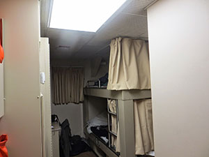
The areas where we sleep on the ship are called staterooms. Almost all of them consist of bunk beds and have a toilet and shower area. I am rooming with Erin, one of the scientists working on the sonar mapping project. Erin and her team work during the night after the ROV runs, so typically she is going to bed shortly before I wake up for the day. We have both been working hard to stay quiet enough to let each other catch up on our sleep!
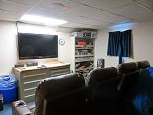
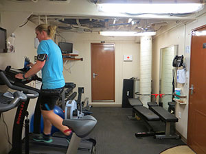
The Shimada has many features that I was not expecting on a ship, such as an exercise room equipped with treadmills and weights. We even have Internet access here! Another unexpected feature is the lounge/ theater room that is across the hall from my stateroom. It has plush reclining chairs, a huge flat screen TV, and all the DVDs you could ever hope to watch, including the newest movies.
When talking with the crew about what they love most about their jobs, many of them referred to how being part of a NOAA boat allows them incredible travel opportunities. One person I spoke with has been to 52 different countries throughout his career with NOAA! Another benefit of a maritime career such as this is that NOAA pays for part of your education. It requires special schooling and credentials to be able to be an engineer or commanding officer on a ship, and NOAA helps offset those costs. One of the biggest challenges of the job, however, is being away from family and friends for such long periods of time. Some of the crew explained to me that they may be out at sea for 30 days at a time, sometimes even longer.
One great perk to life aboard is the food. Two chefs prepare all of the meals on the Shimada for us. Similar to our lunch time at school, the meals are served at the same time each day in what is called the mess hall. If you oversleep and miss breakfast, not too worry; there is cereal and other snacks available around the clock. They serve breakfast, lunch and dinner on the ship, and we have even had the treat of fresh salads and homemade desserts!
The ship stays running smoothly thanks to the help of the engineers and crew members. They work behind the scenes around the clock to keep the ship afloat.
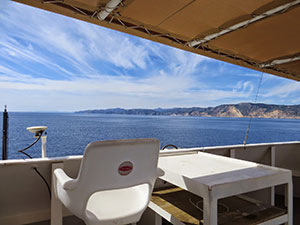
My absolute favorite location on the ship is called the flying bridge. It has 3 tall chairs that look out over the ocean and an almost 360 degree view of the sea. The chairs have been used on previous excursions for scientists to sit and count marine mammals as part of their survey. It is a great place to watch the sunset from.
DAY SIX
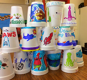
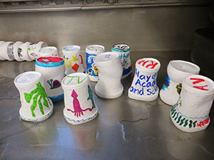
7th and 8th grade students from Haydock Academy of Arts and Sciences in Oxnard, California, along with elementary students from South Carolina, decorated Styrofoam cups that Peter and I took with us on the Shimada. We brought these cups to show our students the amazing power of underwater pressure. The depths at which the ROV and CTD Niskin Rosette traveled during the voyage were much further than a human body could physically handle without being in some sort of pressurized submersible. Human bodies currently experience air pressure when we are at sea level, though we don't feel the pressure because the fluids in our bodies are pressing outwards with the equal amount of force. However, once you start traveling underwater, the greater the pressure of the water pushing down on your being. As one NOAA website states: "For every 33 feet (10.06 meters) you go down, the pressure increases by 14.5 psi. In the deepest ocean, the pressure is equivalent to the weight of an elephant balanced on a postage stamp, or the equivalent of one person trying to support 50 jumbo jets!"
To illustrate how powerful the water pressure is in the deep ocean, Peter and I used Styrofoam cups to demonstrate this concept. First, we stuffed paper towels into the cups so that they would retain their shapes during a dive down to the bottom of the ocean floor. Next, we attached the cups to the CTD niskin rosette. The crew launched the CTD into the ocean and it plunged downwards to a depth of 550 meters. As the cups descended deeper and deeper, the increasing water pressure compressed the air out from between the Styrofoam beads that make up the cup. What was left was a significantly shrunken version of our cups.
The CTD niskin rosette also collected data as it traveled downwards. Water filtered through the machine and sensors gathered information about temperature, salinity, chlorophyll, and dissolved oxygen levels. The tubes on the CTD could also be programmed to collect water samples at certain depths, which they did on the return trip to the surface. This allowed the scientists to collect the water to test for different water quality factors at a later date.
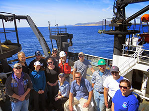
Today, the scientists and Shimada team were joined by media crews from the LA times and the Santa Barbara Independent, along with some of NOAA's education outreach specialists. The reporters took a tour around the Shimada and they interviewed the scientists about their important work. From Peter Etnoyer, and his team's work on Lophelia and ocean acidification, Branwen Williams' research on deep-sea coral, Laura Kracker and team's mapping of uncharted Sanctuary regions, to the MARE team's innovative ROV technology, the media had quite a bit to report about!
The reporters were even able to watch the ROV take its final dive of the trip to collect one last acanthogoria sample. One of Branwen's and Peter's goals is to be able to determine the ages of these beautiful organisms through the work they do. If they are able to create baseline data for how old an acanthogoria is, based on size and height, then there will be less of a need to collect these specimens in the future. Instead, they will be able to determine age based on looking at the footage during an ROV dive and using the laser measurements on the ROV camera to decide how old the coral is.
Until next time... My journey on the Shimada finally came to a close today. NOAA sent out their local research vessel, the Shearwater, to meet us in the waters off Santa Cruz Island. Many of the scientists, along with the MARE team and myself boarded the Shearwater and watched as the Shimada became smaller and smaller in the distance. It was very sad to say goodbye, but Chris Caldow and the sonar team will continue on the Shimada with their important mapping of the Sanctuary for the next several days.
Being able to explore the seldom-visited parts of our sanctuary with the scientists and NOAA crew was a once in a lifetime experience. The research these scientists are doing to unconver the hidden depths of the sanctuary is also helping to illustrate how our actions on land have a direct impact on our oceans.
When we learn more about these rarely seen regions of our Sanctuary and about the deep-sea organisms that make their home there, these places and creatures become something that we grow to love and care about. This exploratory research is so important, because as someone on the trip said; "we cannot protect what we don't know is there." This is especially relevant for myself and the students from Haydock, because the Channel Islands truly are our backyard; we can see the Islands and Sanctuary from the shores of our city of Oxnard. When we feel a greater connection to a place such as the Channel Islands National Marine Sanctuary, we are more likely to take part in the stewardship and protection of it for our future generations.
"Treat the earth well: it was not given to you by your parents, it was loaned to you by your children. We do not inherit the Earth from our Ancestors, we borrow it from our Children" (unknown)