|
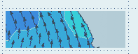
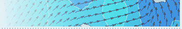
Knowing
the winds over the oceans as well as near the coast are
critical for the safe operation of marine interests. Buoys
and instrumented ships and boats measure winds over the
Ocean. A wind barb is used to represent wind direction and
speed. The longest line points in the direction that the
wind is blowing from. For example, if it is pointing to
the southwest, this represents a southwest wind direction
(see figure below). The shorter lines are called barbs.
They represent the wind speed in knots. The shortest barb
represents 5 knots. A long barb represents 10 knots and
a pennant 50 knots.
Wind blowing from the southwest (225 degrees) at 25 knots.
Arrows can also be used to represent the wind. The arrow
usually points in the direction the wind is moving towards
and the length of the stem of the arrow represents the wind
speed. The longer the stem the higher the wind speed.
|